|
PLEASE NOTE: This data set should be acknowledged:
Panciera, R., Walker, J. P., Jackson, T. J., Gray, D., Tanase, M. A., Ryu, D., Monerris, A., Yardley, H., Rüdiger, C., Wu, X., Gao, Y., Hacker, J., 2014. The Soil Moisture Active Passive Experiments (SMAPEx): Towards Soil Moisture Retrieval from the SMAP Mission. IEEE Transaction on Geoscience and Remote Sensing, 52(1): 490-507
|
Experiment Overview
This third campaign (SMAPEx-3) was conducted in the austral spring from 5-23 September, 2011. Being in spring, this campaign commenced with moist soils and low vegetation biomass, leading to dry soils and high vegetation biomass towards the end of the 3 week long experiment. A particular objective of the third experiment was to acquire long-term series of data throughout the active part of the growing season, with the purpose of testing time-series retrieval algorithms.
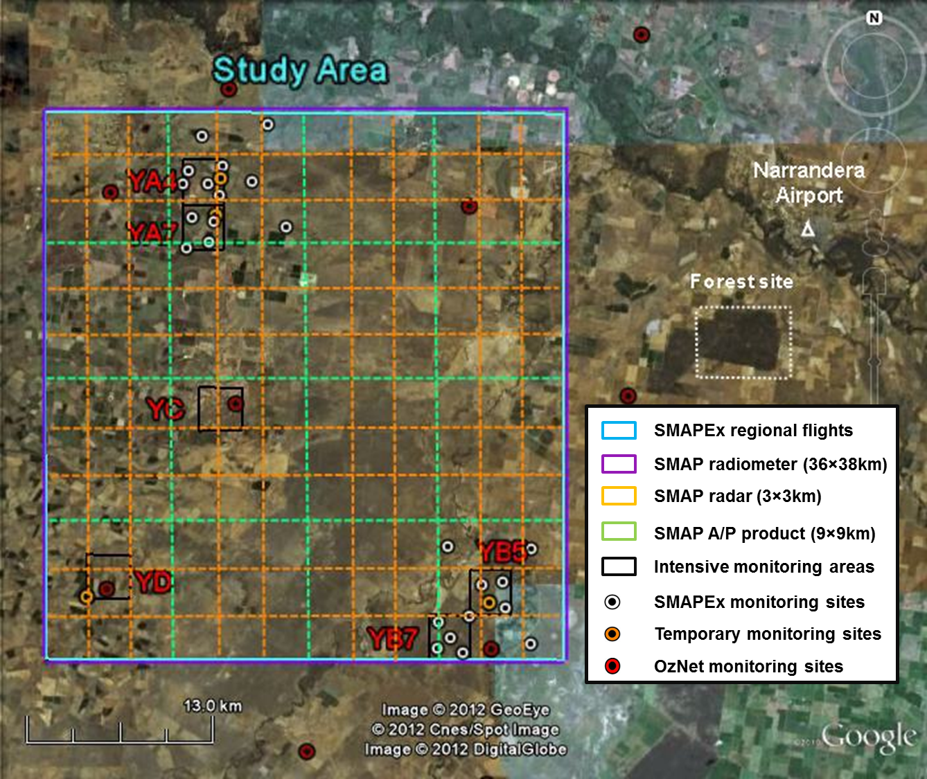
The main airborne and ground monitoring activities followed a “nested grid” approach based on the future SMAP grids. Airborne data were collected over an area equivalent to a single SMAP radiometer pixel (SMAP L1C_TB product, 40km × 40km nominal resolution) for a total of 9 dates over a 3-week period. Continuous ground permanent monitoring sites covered the entire SMAP radiometer pixel, but with a denser network in two sub-areas representing pixels of the SMAP downscaled soil moisture product (SMAP L3_SM_A/P product, 9km × 9km). Intensive spatial monitoring concentrated on six focus areas equivalent to a SMAP radar pixels (L1C_HiRes product, 3km × 3km). This design allowed simulating SMAP prototype data over the Yanco study area by aggregation of the airborne observations to SMAP radiometer and radar resolutions, as well as detailed validation against ground data of the airborne data at all the resolutions of the SMAP products.
The main objective of SMAPEx-3 was to collect airborne active and passive microwave data which were scaled replicate of the data which will be collected by SMAP, supported by ground observations of soil moisture and ancillary data needed for development and validation of algorithms to estimate soil moisture from future SMAP data. On each flight there was airborne acquisition of Polarimetric L-band Multibeam Radiometer (PLMR) and Polarimetric L-band Imaging Scatterometer (PLIS) data as well as supporting thermal radiometers and multispectral radiometers. Intensive ground sampling was undertaken concurrently with the flights and included spatial soil moisture, surface roughness, gravimetric soil sampling, intensive vegetation sampling, vegetation LAI and reflectance measurements, classification of land cover and canopy height, and crop row spacing and direction. In addition to the OzNet and SMAPEx continuous monitoring networks, 4 temporary monitoring sites recorded additional soil moisture and temperature, vegetation skin temperature, leaf wetness and rainfall data during the experiment period.
Complete details on the airborne and ground sampling activities can be found in the experiment plan and workplan addendum. The data collected can be viewed and downloaded from the menu on the sidebar. A summary of the campaign schedule is provided below.
SMAPEx-3
Data collected during SMAPEx-3 consist of:
- airborne L-band active and passive microwave observations, together with ancillary visible, near-infrared, shortwave infrared, and thermal infrared;
- continuous near-surface (top 5cm) soil moisture and soil temperature monitoring at 29 permanent stations across the study area. Of these stations, 5 stations provided profile (0- 90cm) soil moisture and soil temperature data;
- additional intensive measurements of near-surface (top 5cm) soil moisture spatial distribution, vegetation biomass, water content, reflectance, and surface roughness across six approximately 3km × 3km focus areas.
Taking advantage of the SMAPEx-3 experiment set-up, a set of add-on measurements were also acquired:- airbone LIDAR, InSAR, and hyperspectral observations;
- intensive characterisation of four groups of crop plants and 50 forest sites within a 7km × 8km forest area; and
- spatial maps of ground and airborne observations of cosmic-ray fast neutrons above the ground surface.
SMAPEx-3 Schedule
Date (AEST)
Flight type
Altitude
Radiometer Spatial Resolution (m)
Radar
Spatial Resolution(m)Ground Sampling Activities
04/09
Target InSAR
1,440ft
-
10m
-
05/09
Target SAR1km
10-30m
Soil moisture sampling: YA4 & YC
Target LIDAR/VNIR
(crop & trees &bare)1,770ft
-
-
06/09
Target LIDAR/VNIR
(forest)1,770ft
-
-
Intensive crop sampling
07/09
Regional &
Target SAR10,400ft
1km
10-30m
Soil moisture sampling: YB7 & YD
08/09
-
-
-
-
Intensive crop sampling
09/09
Day off
10/09
Regional &
Target SAR10,400ft
1km
10-30m
Soil moisture sampling: YA7 & YB5
11/09
Day off
12/09
-
-
-
-
Intensive crop sampling
13/09
Regional &
Target SAR10,400ft
1km
10-30m
Soil moisture sampling: YA4 & YC
14/09
-
-
-
-
Intensive crop sampling
15/09
Regional &
Target SAR10,400ft
1km
10-30m
Soil moisture sampling: YB7 & YD
16/09
Day off
17/09
Day off
18/09
Regional &
Target SAR10,400ft
1km
10-30m
Soil moisture sampling: YA7 & YB5
19/09
Regional &
Target SAR10,400ft
1km
10-30m
Soil moisture sampling: YA4 & YC
20/09
-
-
-
-
Intensive crop sampling
21/09
Regional &
Target SAR10,400ft
1km
10-30m
Soil moisture sampling: YB7 & YD
22/09
Target LIDAR/VNIR
(crop & trees &bare)1,770ft
-
-
Intensive crop sampling
23/09
Target SAR10,400ft
1km
10-30m
Soil moisture sampling: YA7 & YB5